

RISK RADARS
Detect, predict, protect - instantly.
Stay one step ahead of emerging threats.
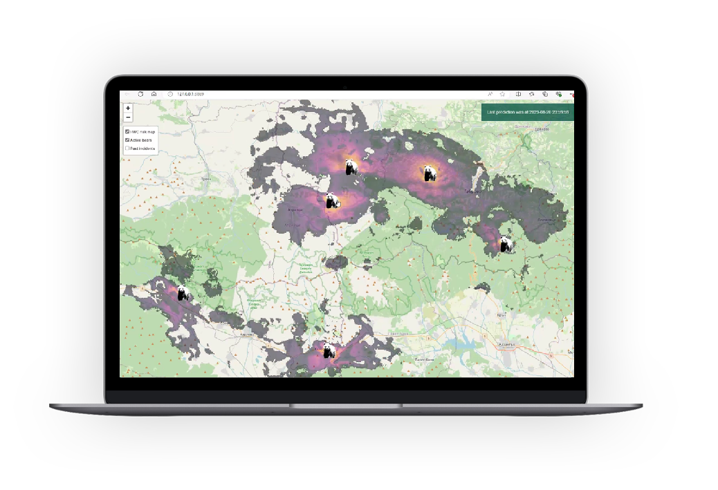
When you’re on the frontlines of conservation, timing is everything. Risk Radars give you the early warning you need to act fast. They help you track wildlife movements, anticipate conflict, and respond with confidence – using live data instead of guesswork.
At the core of each Radar is a digital twin: a real-time virtual model of what’s happening on the ground. Unlike static systems based on past events, our Risk Radars constantly update using live reports – making it easier to manage fast-moving threats like human-wildlife conflict and enabling local teams to step in sooner.
We now have Risk Radars for three species, and more are on the way:
Bear Risk Radars – Bulgaria, Romania, and Ukraine
Sturgeon Risk Radar – Danube Delta, Romania
Crane Migration Radar – The Netherlands
Risk Radars are built with and for those on the ground – so you can make smarter, faster decisions to protect both wildlife and communities.
HOW OUR PARTNERS USE OUR RISK RADARS

“Sensing Clues' real-time data has transformed our approach, helping us track sturgeon behaviour and act quickly to protect this endangered species.”
DDNI, Romania
WILDLIFE PROTECTION

“Using the alerting system of Sensing Clues, we could monitor bears in real-time and act before incidents occurred. This was crucial for reducing conflicts.”
WWF, Romania
HUMAN-WILDLIFE COEXISTENCE
TYPES OF RISK RADARS
An Italian proverb wisely reminds us that “Perfect is the enemy of Good” – a nudge not to let the pursuit of perfection stand in the way of progress.
While still in its early days, the science behind ecological digital twins and Risk Radars already holds life-saving potential. To bring these breakthroughs from lab to field and support human-wildlife coexistence, we’re working on three progressively advanced Risk Radars.
-
The Radius Risk Radar offers a real-time view of on-the-ground activity and estimates the likely movement of animals in the hours after a sighting. It combines live sightings shared by community members with species-specific dispersal data, such as average and maximum movement per hour. Technically, the Radius Radar can be up and running within a day. Organisationally, it requires a community manager to serve as a link between the local community and our technical support team.
-
The Advanced Risk Radar builds on the Radius Risk Radar by adding landscape features, species traits, and statistical modelling to improve prediction accuracy. It can typically be set up within a few weeks, depending on the availability of local data and knowledge. Alongside a community manager, the input of a (local) species expert is essential.
-
Research Risk Radars - also known as ecological digital twins - form an emerging and dynamic research field. New species, hypotheses, and theoretical frameworks are continuously explored and integrated, keeping these systems at the forefront of innovation. In addition to a community manager and local species expert, one or more (PhD) researchers are involved to test and validate new hypotheses.
CREDITS
Risk Radars have been developed by Nature FIRST, a Research and Innovation Action (RIA) from HORIZON-CL6-2021-BIODIV-01-02 Call (grant Agreement ID 101060954) that has received funding from the European Union’s Horizon Europe Research and Innovation programme.
Risks Radars are an initiative of:
